
If you love staring at maps, you’ll absolutely love learning about US megaregions. Just beware that no one exactly knows what a megaregion is, how many there are, and whether they’re important. Let’s dive in.
A Definition
As above, the definition of a megaregion can be hard to come by. Below are two, taken directly from this excellent article.
The fusing of two or more metropolitan areas and their hinterlands.
A large connected network of metro areas joined together by environmental, cultural, infrastructural, and functional characteristics. The metro areas must share fundamental interests (such as economic ones), not just boundaries.
You’re probably slightly confused and, if not, thinking that the exact number of these things is somewhat arbitrary.
So far so good.
The Significance
This is where things get even more nebulous. There’s a school of thought that this entire concept lies squarely in the domain of scholars, meaning that practical implications, if present, are few.
In other words, beyond the occasional examples of shared transportation (e.g. Amtrak in the Northeast) and common environmental concerns, the idea of megaregions may be nothing more than an idea.
After all, these regions cross a huge range of jurisdictions, including cities, counties, states, and—in some cases—countries. Achieving coordinated activity from such a wide spectrum of players can be nearly impossible.
Furthermore, in an era of mind-blowing technology and abundant air travel, simple geographic proximity may not have the same relevance as it did in years past. Stated another way, just because cities appear unified on aerial nighttime images doesn’t mean they’re actually working together.
Therefore, it’s possible that all this fancy talk doesn’t amount to much beyond being able to look at some really cool maps.
A Really Cool Map
According to the Regional Plan Association, a non-profit planning organization based in New York City, there are 11 US megaregions. Here’s what they look like, courtesy IrvingPINYC.
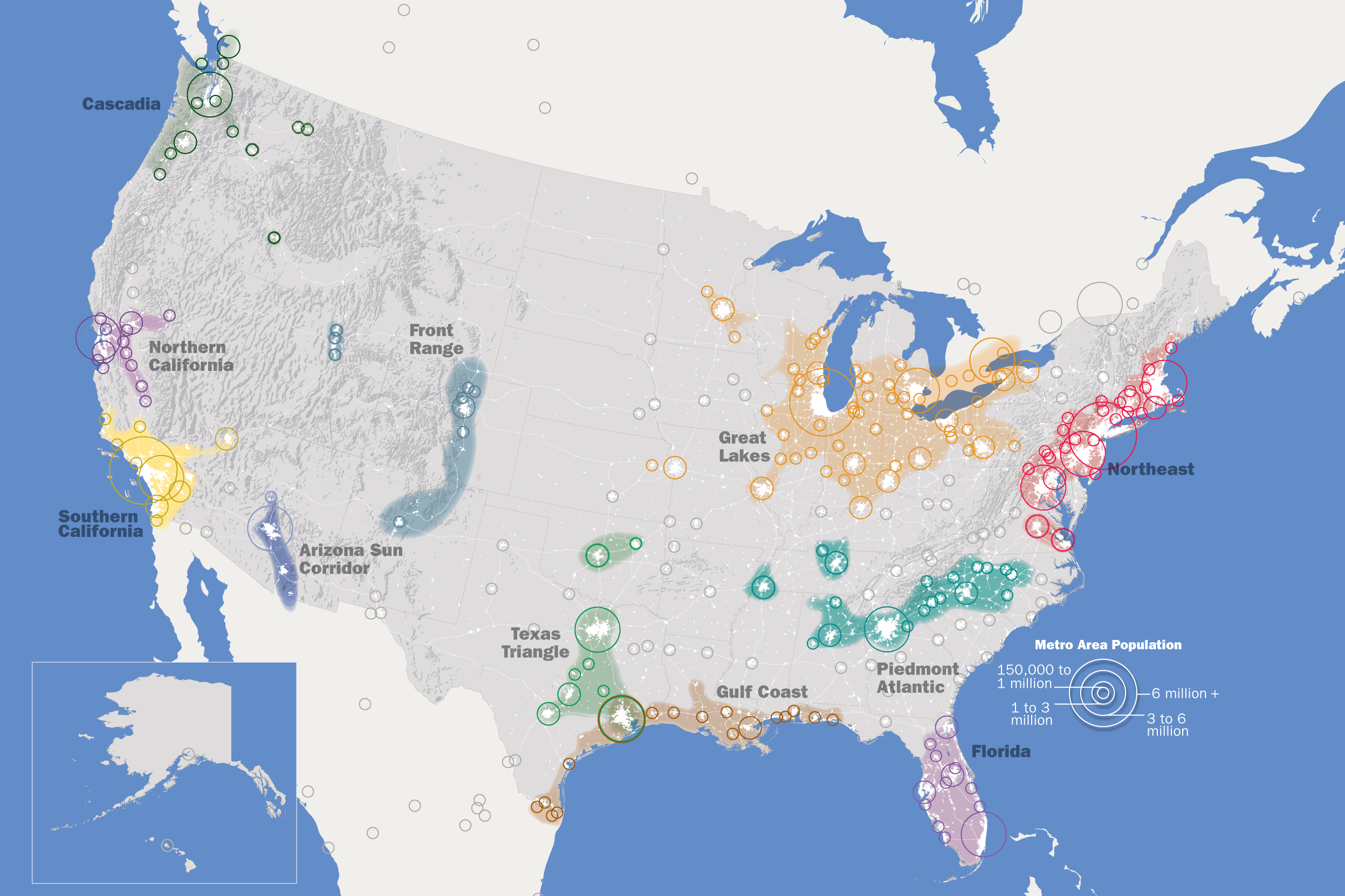
A Table
And here’s the above map in table format, adapted from Wikipedia.
| Megaregion | Projected 2025 Population in Millions | Notes |
|---|---|---|
| Arizona Sun Corridor | 7.8 | Fastest growing region. Extends into Mexico. |
| Cascadia | 13.5 | Extends into Canada. |
| Florida | 21.5 | Does not include the entire state. |
| Front Range | 6.9 | Think Denver. |
| Great Lakes | 60.7 | Extends into Canada. |
| Gulf Coast | 16.3 | Overlaps with Texas Triangle, specifically Houston. Extends into Mexico. |
| Northeast | 58.4 | |
| Northern California | 16.4 | Extends into Nevada. |
| Piedmont Atlantic | 21.7 | Think Charlotte and Atlanta. |
| Southern California | 29 | Extends into Mexico. |
| Texas Triangle | 24.8 | Extends into Oklahoma. |
All told, these megaregions account for approximately 80% of the US population.
A Celebration
You might have noticed that the largest entity above is the Great Lakes megaregion. That’s right—after years of being derisively labeled as the Rust Belt and flyover country, not to mention being mocked for a dearth of sunshine and excess snow, it turns out that the Great Lakes region is king of the world’s largest economy! (Yes, this ranking includes a large chunk of Canada and doesn’t reference GDP, but now’s not the time for minor details.)
Even The White Stripes knew as early as 2001 that the frigid middle is where it’s at. Why else would they have written a song that mentions Toledo—three times?!